More space for bikes and trams on innercity ring
There was once an idea to build an elevated highway around the historic centre of Amsterdam. Fortunately, this never became a reality and instead, an essential route for bicycles and public transport known as the inner ring was constructed at about the same location. This ring road consists of the Sarphatistraat, the Weteringschans and the Marnixstraat. By reducing car traffic, more space and improve safety for public transport and bicycles were provided. The inner ring now serves as a route whereby the people travelling by bike and public transportation along its route, could fit in cars on the envisioned elevated highway. Below you will find more information about the creation of the Amsterdam inner ring as well as, recent and upcoming measures.
Improving mobility
The fundamental design for the inner ring was constructed in the 1970s as one of the measures to improve the city’s mobility. The inner ring provided an accessible tramway in addition to more space and safety for cyclists. Ongoing car traffic was made impossible by several measures. These measures included cut-offs to cars like at Weesperplein and, alternating one-way traffic for cars implemented on the Weteringschans. At the intersection of Weteringschans and Museum Bridge, the alternating direction of travel for cars is clearly visible: the roadway and tramway cross section in the profile.

At the Museum Bridge, car traffic cannot drive along the inner ring. Photo: Marjolein de Lange.
Resistance, but also success
Retailers highly objected to the transformation of the street as they feared a loss of income if it would be harder for cars to reach their shops. Nonetheless, once the reconstruction was completed, the inner ring proved to be a success at least in terms of traffic and ultimately also for the retailers. A year after construction, the number of cyclists increased by 56%, trams had an average reduction of three minutes in delay over the entire route and car traffic on the inner ring halved. Ongoing car traffic from then on followed the route just outside the Singelgracht via Mauritskade, Stadhouderskade and Nassaukade thereby forming the main car network.
Transformation into a bicycle street
Since the 1980s, bicycle traffic has grown considerably, including traffic on the inner ring. In around 2012, bicycle lanes of 2.5 meters wide were constructed to give cyclists more and more obvious space on the inner ring. Since 2016, the municipality has been successively converting the parts of the inner ring where cars drive into a bicycle street. This conversion began in the northern part of Sarphatistraat.
The evaluation report of bicycle street Sarphatistraat. (download, Dutch)
Solutions
To provide space for the large number of cyclists, we are also improving the intersections. Some examples:
- At the intersection with Zeeburgerstraat, the queuing space for cyclists has been increased.
- At Alexanderplein, the traffic lights have been removed and the priority has been reversed.
- At the intersection with Weesperzijde – at Professor Tulpplein – the queuing space has been increased and made more explicit by using lines.
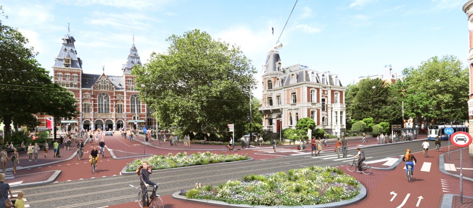
- At Museumbrug there will be more and more apparent space for cyclists.

Artist impression of the design for intersection Weteringschans – Museum Bridge. Image: Municipality of Amsterdam.
Figures
The inner ring road is used daily by:
- 20,000 cyclists (2016 count);
- Approximately 28,000 tram passengers (2019 count);
- 2,700 car drivers (2017).
In comparison, about 23,600 cars travel via Stadhouderskade daily (2017).
About as many people now ride bicycles and use the tram on the inner ring road as could have been carried by cars on the highway which was once conceived here. And the retailers? They now flourish thanks to the excellent accessibility by bicycle.

Impression of a motorway around the historic city centre. In the middle, the Leidseplein, now home to the inner ring. Image: Das brothers in the booklet In search of living space, ca 1968.
Please, share your experience with our community!
Can you think of any streets in your city where bicycles and public transport have been given space by reducing the number of cars? How was this achieved?


